Please use BACK BUTTON ON BROWSER to return to main list
OLD 1860 JOHNSON’S COLOR MAP OF UPPER & LOWER CANADA
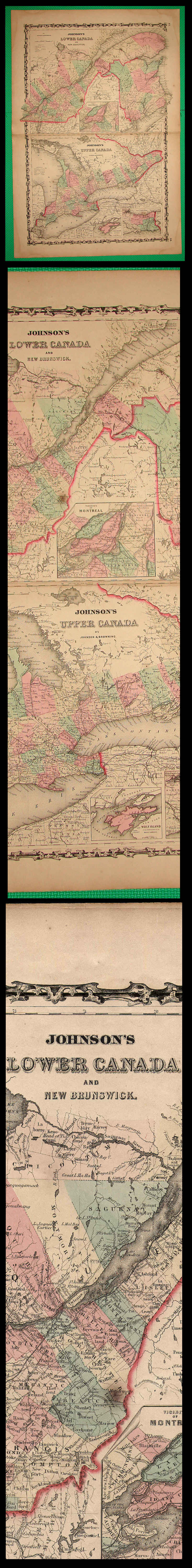
This is a fine old map about 18 x 27" neatly removed from an 1860 atlas published by Johnson & Browning in Richmond, Virginia. The various parts of the provinces are colored in with green, pink, & yellow, and some borders of the provinces are outlined in darker red. A complete description of this map follows:
Johnson's LOWER CANADA AND NEW BRUNSWICK, with an inset map of the City of Montreal (upper half of the map), and Johnson’s UPPER CANADA, with inset maps of Wolf Island & Welland Canal and Niagara Falls, by Johnson & Browning. Page No. 17 & 18 as published in:
JOHNSON'S NEW ILLUSTRATED (STEEL PLATE) FAMILY ATLAS, With Descriptions, Geographical, Statistical, And Historical. Compiled, Drawn, and Engraved Under The Supervision Of J.H. Colton And A.J. Johnson. Published by Johnson And Browning, Formerly (Successors To J.H. Colton And Company,) Tenth Street (Second Door from Main), RICHMOND, VIRGINIA, 1860. Entered ... One Thousand Eight Hundred and Sixty, by Johnson & Browning ... Virginia. Printed by Charles H. Wynne, 94 Main Street, Richmond, VA.
Map has a few light stains and spots and some small tears & splitting around the edges. The map is weak along its vertical fold-line, but has not separated. Otherwise, the map is in good condition. The reverse side is blank. This map would be quite displayable if matted and framed. Scan shows full-size map at top, scroll down for enlarged detail & actual coloration of the map.
Price= $65.00
Please use BACK BUTTON ON BROWSER to return to main list
ORDERING
INFORMATION
BACK TO HISTORY BROKER HOMEPAGE